AFSIS1
AFSIS1
Soil spectral library from Africa Soil Information Service Phase I (AFSIS1)
1,000+ samples
first release (v1)
CC-BY
Database access
Data originally provided by:
- Contact: Keith Shepherd
- Email: afsis.info@africasoils.net
- Original source: https://data.worldagroforestry.org/dataset.xhtml?persistentId=doi:10.34725/DVN/QXCWP1
Available files
| Type | Filename | Link |
|---|---|---|
| MIR spectra — CSV (gzip) | ossl_mir_v1.3.csv.gz |
Download |
| MIR spectra — Parquet | ossl_mir_v1.3.parquet |
Download |
| Soil lab measurements — CSV (gzip) | ossl_soillab_v1.3.csv.gz |
Download |
| Soil lab measurements — Parquet | ossl_soillab_v1.3.parquet |
Download |
| Soil site metadata — CSV (gzip) | ossl_soilsite_v1.3.csv.gz |
Download |
| Soil site metadata — Parquet | ossl_soilsite_v1.3.parquet |
Download |
Map
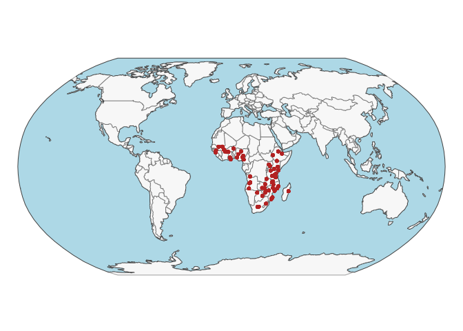
Soil site information
- Coordinates precision: precise, country
- Sampling depth: various
- Geography: soil taxonomy, landuse
- Variables available (OSSL): 16 out of 16 — see Database description for full schema
- Populated columns:
id.layer_uuid_txt,id.layer_local_c,latitude.point_wgs84_dd,longitude.point_wgs84_dd,surveyor.title_utf8_txt,site.cluster_src_id,site.plot_src_id,site.name_src_txt,loc.country_src_txt,loc.region_src_txt,site.cultivated_src_logical,observation.date.begin_iso.8601_yyyy.mm.dd,observation.date.end_iso.8601_yyyy.mm.dd,layer.upper.depth_usda_cm,layer.lower.depth_usda_cm,layer.sequence_usda_uint16
Soil laboratory information
- Total samples: 1,907
- Properties available (original): 23
- Properties standardized (OSSL): 20 — summarized in Table 1 below
- Categories: physical, chemical, carbon & nutrients, metal elements
- Original source: see Database access
Hover over any OSSL code in the table below to see its full description.
| skim_variable | n_missing | mean | sd | p0 | p25 | p50 | p75 | p100 |
|---|---|---|---|---|---|---|---|---|
ec_usda.a364_ds.mElectrical Conductivity, (w/w)Method: usda.a364Unit: ds.m |
0 | 0.13 | 0.39 | 0.01 | 0.03 | 0.06 | 0.11 | 8.73 |
al.ext_usda.a1056_mg.kgAluminum, Extractable, Mehlich3Method: usda.a1056Unit: mg.kg |
0 | 821.58 | 466.22 | 1.67 | 457.00 | 733.00 | 1109.50 | 3041.00 |
b.ext_mel3_mg.kgBoron, Extractable, Mehlich3Method: mel3Unit: mg.kg |
2 | 0.44 | 1.79 | 0.00 | 0.00 | 0.10 | 0.36 | 55.09 |
ca.ext_usda.a1059_mg.kgCalcium, Extractable, Mehlich3Method: usda.a1059Unit: mg.kg |
0 | 1841.05 | 3438.81 | 0.00 | 290.00 | 634.00 | 1693.50 | 35200.00 |
cu.ext_usda.a1063_mg.kgCopper, Extractable, Mehlich3Method: usda.a1063Unit: mg.kg |
0 | 1.77 | 2.06 | 0.00 | 0.50 | 1.12 | 2.42 | 23.70 |
fe.ext_usda.a1064_mg.kgIron, Extractable, Mehlich3Method: usda.a1064Unit: mg.kg |
0 | 112.11 | 81.46 | 1.26 | 60.05 | 91.90 | 139.10 | 981.00 |
k.ext_usda.a1065_mg.kgPotassium, Extractable, Mehlich3Method: usda.a1065Unit: mg.kg |
0 | 173.99 | 289.98 | 0.00 | 51.48 | 91.41 | 177.85 | 5047.00 |
mg.ext_usda.a1066_mg.kgMagnesium, Extractable, Mehlich3Method: usda.a1066Unit: mg.kg |
0 | 311.58 | 416.64 | 0.00 | 79.15 | 159.00 | 383.95 | 4740.00 |
mn.ext_usda.a1067_mg.kgManganese, Extractable, Mehlich3Method: usda.a1067Unit: mg.kg |
0 | 98.93 | 100.63 | 0.57 | 24.00 | 69.40 | 139.00 | 686.60 |
na.ext_usda.a1068_mg.kgSodium, Extractable, Mehlich3Method: usda.a1068Unit: mg.kg |
6 | 140.34 | 1169.35 | 0.00 | 22.30 | 34.30 | 50.92 | 31800.00 |
p.ext_usda.a652_mg.kgPhosphorus, Extractable, Mehlich3Method: usda.a652Unit: mg.kg |
0 | 12.30 | 28.75 | 0.00 | 2.55 | 4.97 | 10.09 | 396.00 |
s.ext_mel3_mg.kgSulphur, Extractable, Mehlich3Method: mel3Unit: mg.kg |
2 | 24.87 | 165.80 | 0.62 | 5.00 | 7.62 | 12.40 | 3940.00 |
zn.ext_usda.a1073_mg.kgZinc, Extractable, Mehlich3Method: usda.a1073Unit: mg.kg |
0 | 1.53 | 1.77 | 0.00 | 0.71 | 1.10 | 1.75 | 36.51 |
ph.h2o_usda.a268_indexpH, 1:1 Soil-Water SuspensionMethod: usda.a268Unit: index |
0 | 6.21 | 1.07 | 3.61 | 5.44 | 6.08 | 6.69 | 9.86 |
n.tot_usda.a623_w.pctNitrogen, Total NCS, usda.a623Method: usda.a623Unit: w.pct |
2 | 0.08 | 0.08 | 0.00 | 0.03 | 0.05 | 0.10 | 0.66 |
c.tot_usda.a622_w.pctCarbon, Total NCSMethod: usda.a622Unit: w.pct |
2 | 1.24 | 1.34 | 0.08 | 0.42 | 0.78 | 1.51 | 11.29 |
oc_usda.c1059_w.pctOrganic Carbon, Total C without CaCO3, N prepMethod: usda.c1059Unit: w.pct |
2 | 1.18 | 1.28 | 0.07 | 0.39 | 0.73 | 1.46 | 10.93 |
clay.tot_usda.a334_w.pctClayMethod: usda.a334Unit: w.pct |
8 | 42.99 | 24.09 | 0.32 | 22.16 | 40.16 | 63.13 | 100.00 |
silt.tot_usda.c62_w.pctSilt, Total, S prepMethod: usda.c62Unit: w.pct |
14 | 17.73 | 10.05 | 0.34 | 10.00 | 16.48 | 23.42 | 57.27 |
sand.tot_usda.c60_w.pctSand, Total, S prepMethod: usda.c60Unit: w.pct |
13 | 39.50 | 26.20 | 0.12 | 15.72 | 36.96 | 60.31 | 100.00 |
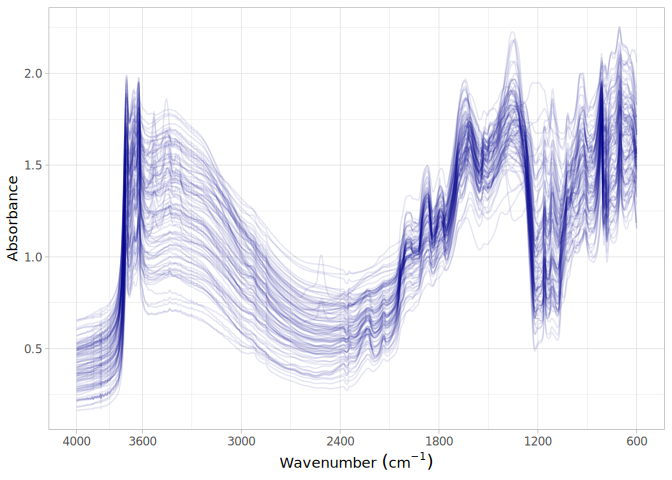
MIR
- Acquisition mode: Not available
- Intensity: absorbance
- Original range: 602-4000
- Standardized range: 600-4000
- Instrument: Tensor 27 FT-IR & Alpha I ZnSe
- Manufacturer: Bruker Optics
- Scan accessory: Not available
- Sample preparation: Finely ground <0.1 mm
- Additional info: Not available
MIR plot