MTQ
MTQ
Near-infrared soil spectral library from rural areas of the Martinique island (MTQ)
<1,000 samples
version 3.1
CC-BY
Database access
Data originally provided by:
- Contact: Aurélie Cambou
- Email: aurelie.cambou@ird.fr
- Original source: https://dataverse.ird.fr/dataset.xhtml?persistentId=doi:10.23708/C2TV6W
Available files
| Type | Filename | Link |
|---|---|---|
| NIR spectra — CSV (gzip) | ossl_nir_v1.3.csv.gz |
Download |
| NIR spectra — Parquet | ossl_nir_v1.3.parquet |
Download |
| Soil lab measurements — CSV (gzip) | ossl_soillab_v1.3.csv.gz |
Download |
| Soil lab measurements — Parquet | ossl_soillab_v1.3.parquet |
Download |
| Soil site metadata — CSV (gzip) | ossl_soilsite_v1.3.csv.gz |
Download |
| Soil site metadata — Parquet | ossl_soilsite_v1.3.parquet |
Download |
Map
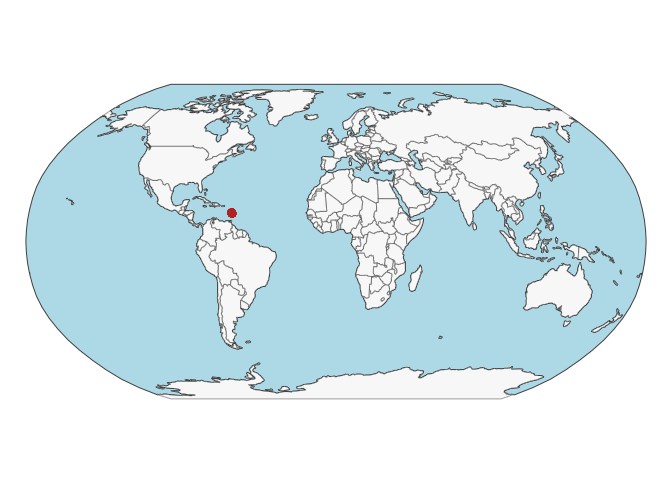
Soil site information
- Coordinates precision: precise
- Sampling depth: various
- Geography: soil taxonomy, landuse
- Variables available (OSSL): 13 out of 13 — see Database description for full schema
- Populated columns:
id.layer_uuid_txt,id.layer_local_c,site.id_src_txt,loc.region_src_txt,loc.municipality_src_txt,latitude.point_wgs84_dd,longitude.point_wgs84_dd,pedon.taxa_src_txt,site.land.use_src_txt,site.land.history_src_txt,layer.upper.depth_usda_cm,layer.lower.depth_usda_cm,layer.sequence_usda_uint16
Soil laboratory information
- Total samples: 516
- Properties available (original): 13
- Properties standardized (OSSL): 12 — summarized in Table 1 below
- Categories: physical, carbon & nutrients
- Original source: see Database access
Hover over any OSSL code in the table below to see its full description.
| skim_variable | n_missing | mean | sd | p0 | p25 | p50 | p75 | p100 |
|---|---|---|---|---|---|---|---|---|
oc_iso.10694_w.pctOrganic Carbon, ISO 10694Method: iso.10694Unit: w.pct |
0 | 1.60 | 1.19 | 0.09 | 0.74 | 1.33 | 2.08 | 8.85 |
n.tot_iso.13878_w.pctNitrogen, Total NCS, ISO 13878Method: iso.13878Unit: w.pct |
0 | 0.15 | 0.10 | 0.01 | 0.07 | 0.13 | 0.18 | 0.62 |
clay.tot_iso.11277_w.pctClay, ISO 11277Method: iso.11277Unit: w.pct |
222 | 43.10 | 21.94 | 3.30 | 21.00 | 50.40 | 61.30 | 82.40 |
| bd_iso.11277_g.cm3 | 0 | 0.92 | 0.18 | 0.35 | 0.79 | 0.92 | 1.04 | 1.49 |
cf_iso.11464_w.pctCoarse Fragments, ISO 11464Method: iso.11464Unit: w.pct |
344 | 38.81 | 15.16 | 2.10 | 29.10 | 39.15 | 46.87 | 88.90 |
sand.tot_iso.11277_w.pctSand, Total, ISO 11277Method: iso.11277Unit: w.pct |
222 | 36.47 | 21.93 | 2.30 | 18.22 | 29.35 | 58.05 | 87.90 |
silt.tot_iso.11277_w.pctSilt, Total, ISO 11277Method: iso.11277Unit: w.pct |
222 | 20.46 | 6.14 | 6.40 | 16.70 | 21.05 | 25.10 | 34.30 |
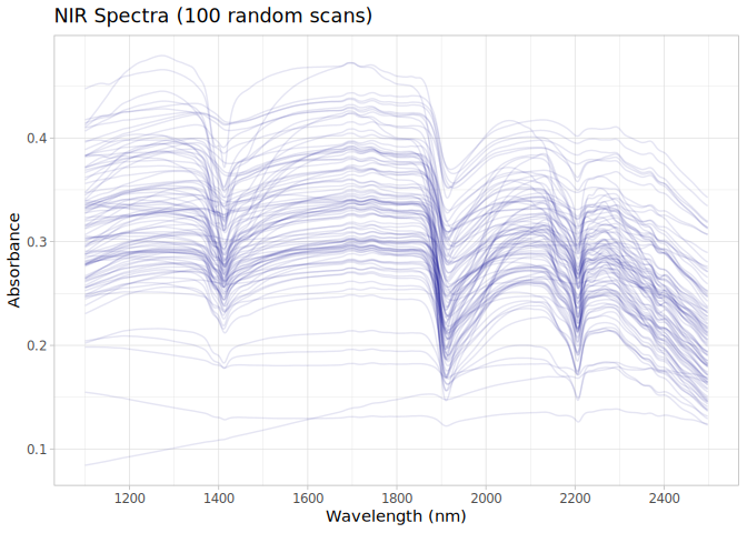
NIR
- Acquisition mode: Not available
- Intensity: reflectance
- Original range: 1100-2498
- Instrument: Foss NIRSystems 5000 spectrophotometer
- Manufacturer: Laurel, MD, USA; 2003
- Instrument co-scans: 32
- Scan repeats: 2
- Scan accessory: Not available
- Original resolution: 2 nm
- Sample preparation: Oven-dried, Sieved < 2mm
- Additional info: Not available
NIR plot