AUT
AUT
Austrian NIR soil spectral library for soil health assessments (AUT)
2,000+ samples
version v4
CC-BY
Database access
Data originally provided by:
- Contact: Julia Fohrafellner
- Email: julia.fohrafellner@ages.at
- Original source: https://zenodo.org/records/17941270
Available files
| Type | Filename | Link |
|---|---|---|
| NIR spectra — CSV (gzip) | ossl_nir_v1.3.csv.gz |
Download |
| NIR spectra — Parquet | ossl_nir_v1.3.parquet |
Download |
| Soil lab measurements — CSV (gzip) | ossl_soillab_v1.3.csv.gz |
Download |
| Soil lab measurements — Parquet | ossl_soillab_v1.3.parquet |
Download |
| Soil site metadata — CSV (gzip) | ossl_soilsite_v1.3.csv.gz |
Download |
| Soil site metadata — Parquet | ossl_soilsite_v1.3.parquet |
Download |
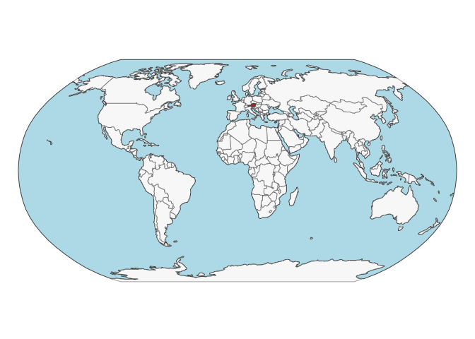
Map
Soil site information
- Coordinates precision: county
- Sampling depth: various
- Geography: landuse, vegetation
- Variables available (OSSL): 11 out of 11 — see Database description for full schema
- Populated columns:
id.layer_uuid_txt,id.layer_local_c,observation.date_src_yyyy,loc.experiment_src_txt,observation.source_src_txt,loc.municipality_src_code,loc.env.zone_src_txt,site.land.use_src_txt,layer.upper.depth_usda_cm,layer.bottom.depth_usda_cm,layer.sequence_usda_uint16
Soil laboratory information
- Total samples: 2,131
- Properties available (original): 13
- Properties standardized (OSSL): 10 — summarized in Table 1 below
- Categories: physical, chemical, carbon & nutrients
- Original source: see Database access
Hover over any OSSL code in the table below to see its full description.
| skim_variable | n_missing | mean | sd | p0 | p25 | p50 | p75 | p100 |
|---|---|---|---|---|---|---|---|---|
oc_usda.c729_w.pctOrganic Carbon, Total C without CaCO3, S prepMethod: usda.c729Unit: w.pct |
19 | 2.76 | 3.20 | 0.02 | 1.53 | 1.96 | 2.71 | 44.82 |
c.tot_usda.a622_w.pctCarbon, Total NCSMethod: usda.a622Unit: w.pct |
2039 | 6.54 | 6.23 | 1.00 | 2.63 | 4.90 | 6.66 | 39.08 |
caco3_usda.a54_w.pctCarbonate, <2mm FractionMethod: usda.a54Unit: w.pct |
1804 | 13.26 | 12.57 | 0.01 | 4.30 | 9.70 | 20.40 | 81.90 |
n.tot_usda.a623_w.pctNitrogen, Total NCS, usda.a623Method: usda.a623Unit: w.pct |
1095 | 0.25 | 0.21 | 0.03 | 0.16 | 0.19 | 0.25 | 2.42 |
p.ext_austria.cal_mg.kgPhosphorus, Extractable, Calcium-Acetate-Lactate (CAL)Method: austria.calUnit: mg.kg |
488 | 112.89 | 136.73 | 1.00 | 45.00 | 78.00 | 120.00 | 1623.53 |
ph.cacl2_iso.10390_indexpH, 1:5 Soil-CaCl2 Suspension, ISO 10390Method: iso.10390Unit: index |
214 | 6.92 | 0.85 | 3.18 | 6.60 | 7.26 | 7.51 | 7.93 |
cec_iso.11260_cmolc.kgCEC, BaCl2, soil's own pH, ISO 11260Method: iso.11260Unit: cmolc.kg |
1490 | 20.91 | 8.75 | 2.88 | 15.81 | 20.95 | 24.42 | 85.45 |
sand.tot_iso.11277_w.pctSand, Total, ISO 11277Method: iso.11277Unit: w.pct |
1569 | 36.25 | 18.69 | 5.60 | 21.00 | 32.20 | 49.48 | 92.50 |
silt.tot_iso.11277_w.pctSilt, Total, ISO 11277Method: iso.11277Unit: w.pct |
1569 | 45.71 | 14.26 | 5.00 | 35.80 | 47.10 | 56.70 | 75.70 |
clay.tot_iso.11277_w.pctClay, ISO 11277Method: iso.11277Unit: w.pct |
1597 | 18.01 | 9.05 | 1.50 | 10.93 | 17.30 | 23.80 | 47.10 |
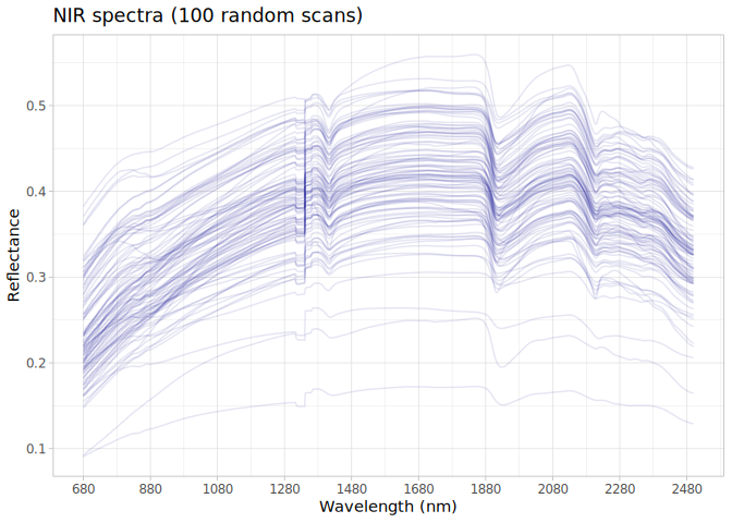
NIR
- Acquisition mode: Not available
- Intensity: reflectance
- Original range: 680-2500
- Instrument: SpectraStar™ XL
- Manufacturer: Unity Scientific (Brookfield, CT, USA)
- Instrument co-scans: 24
- Scan repeats: 2
- Scan accessory: Not available
- Original resolution: 1 nm
- Sample preparation: Air-dried, Sieved < 2 mm
- Additional info: A mattesurface gold-plated metal reflector was used as an internal reference; The standard used was White Sand (Lucky Bay, Australia), which enables harmonizing results from different near-infrared spectrometers used within the ProbeField project.
NIR plot