LUCAS
LUCAS
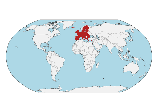
Land Use and Cover Survey (LUCAS) library from European soils (23-28 countries)
20,000+ samples
2009, 2012, 2015
Other (Custom) with redistribution permission upon spatial anonymization
Database access
Data originally provided by:
- Contact: European Soil Data Centre (ESDAC)
- Email: panos.panagos@ec.europa.eu
- Original source: https://esdac.jrc.ec.europa.eu/resource-type/soil-point-data
Available files
| Type | Filename | Link |
|---|---|---|
| MIR spectra — CSV (gzip) | ossl_mir_v1.3.csv.gz |
Download |
| MIR spectra — Parquet | ossl_mir_v1.3.parquet |
Download |
| Soil lab measurements — CSV (gzip) | ossl_soillab_v1.3.csv.gz |
Download |
| Soil lab measurements — Parquet | ossl_soillab_v1.3.parquet |
Download |
| Soil site metadata — CSV (gzip) | ossl_soilsite_v1.3.csv.gz |
Download |
| Soil site metadata — Parquet | ossl_soilsite_v1.3.parquet |
Download |
| VisNIR spectra — CSV (gzip) | ossl_visnir_v1.3.csv.gz |
Download |
| VisNIR spectra — Parquet | ossl_visnir_v1.3.parquet |
Download |
Map
Soil site information
- Coordinates precision: precise, country
- Sampling depth: top
- Geography: soil taxonomy, elevation, landuse
- Variables available (OSSL): 12 out of 12 — see Database description for full schema
- Populated columns:
id.layer_uuid_txt,id.layer_local_c,longitude.point_wgs84_dd,latitude.point_wgs84_dd,loc.country_src_txt,site.landuse2009_src_code,site.landuse2012_src_code,layer.upper.depth_usda_cm,layer.lower.depth_usda_cm,observation.date.begin_iso.8601_yyyy.mm.dd,observation.date.end_iso.8601_yyyy.mm.dd,site.landuse2015_src_code
Soil laboratory information
- Total samples: 43,925
- Properties available (original): 13
- Properties standardized (OSSL): 13 — summarized in Table 1 below
- Categories: physical, chemical, carbon & nutrients, metal elements
- Original source: see Database access
Hover over any OSSL code in the table below to see its full description.
| skim_variable | n_missing | mean | sd | p0 | p25 | p50 | p75 | p100 |
|---|---|---|---|---|---|---|---|---|
cf_iso.11464_w.pctCoarse Fragments, ISO 11464Method: iso.11464Unit: w.pct |
17601 | 14.89 | 13.09 | 0.00 | 5.00 | 11.00 | 21.00 | 92.00 |
clay.tot_iso.11277_w.pctClay, ISO 11277Method: iso.11277Unit: w.pct |
17628 | 19.69 | 14.63 | 0.00 | 8.00 | 17.00 | 28.00 | 96.00 |
silt.tot_iso.11277_w.pctSilt, Total, ISO 11277Method: iso.11277Unit: w.pct |
17630 | 37.24 | 19.06 | 0.00 | 24.00 | 38.00 | 51.00 | 93.00 |
sand.tot_iso.11277_w.pctSand, Total, ISO 11277Method: iso.11277Unit: w.pct |
17628 | 38.78 | 26.01 | 0.00 | 16.00 | 36.00 | 59.00 | 100.00 |
ph.h2o_iso.10390_indexpH, 1:5 Soil-Water Suspension, ISO 10390Method: iso.10390Unit: index |
2 | 6.19 | 1.34 | 3.17 | 5.02 | 6.18 | 7.48 | 10.37 |
ph.cacl2_iso.10390_indexpH, 1:5 Soil-CaCl2 Suspension, ISO 10390Method: iso.10390Unit: index |
2 | 5.71 | 1.40 | 2.57 | 4.50 | 5.76 | 7.10 | 10.00 |
oc_iso.10694_w.pctOrganic Carbon, ISO 10694Method: iso.10694Unit: w.pct |
249 | 4.52 | 8.22 | 0.01 | 1.26 | 2.02 | 3.79 | 58.68 |
caco3_iso.10693_w.pctCarbonate, ISO 10693Method: iso.10693Unit: w.pct |
697 | 5.44 | 13.05 | 0.00 | 0.00 | 0.10 | 1.60 | 97.60 |
n.tot_iso.11261_w.pctNitrogen, Total NCS, ISO 11261Method: iso.11261Unit: w.pct |
7 | 0.30 | 0.36 | 0.00 | 0.12 | 0.18 | 0.30 | 3.86 |
p.ext_iso.11263_mg.kgPhosphorus, Extractable, ISO 11263Method: iso.11263Unit: mg.kg |
697 | 31.21 | 32.69 | 0.00 | 10.90 | 22.70 | 43.00 | 1366.40 |
k.ext_usda.a725_cmolc.kgPotassium, Extractable, NH4OAc, 2M KCl displacementMethod: usda.a725Unit: cmolc.kg |
2 | 1.02 | 1.18 | 0.00 | 0.39 | 0.74 | 1.29 | 51.31 |
cec_iso.11260_cmolc.kgCEC, BaCl2, soil's own pH, ISO 11260Method: iso.11260Unit: cmolc.kg |
21882 | 17.31 | 15.19 | 0.00 | 7.50 | 13.50 | 22.80 | 234.00 |
ec_iso.11265_ds.mElectrical Conductivity, ISO 11265Method: iso.11265Unit: ds.m |
22066 | 0.26 | 0.33 | 0.00 | 0.10 | 0.17 | 0.28 | 9.69 |
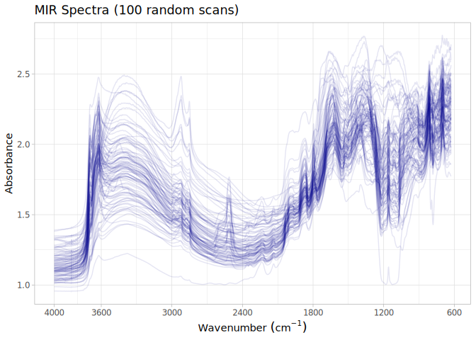
MIR
- Acquisition mode: Not available
- Intensity: absorbance
- Original range: 600-4000
- Standardized range: 628-4000
- Instrument: Vertex 70 FT-IR
- Manufacturer: Bruker Optics
- Scan accessory: Not available
- Sample preparation: Air-dried, finely ground <0.2 mm
- Additional info: KBr beamsplitter; Gold mirror; Mirror background
MIR plot
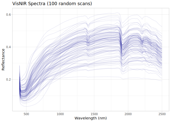
VNIR
- Acquisition mode: Not available
- Intensity: reflectance
- Original range: 400-2500
- Instrument: FOSS NIRS XDS RapidContent Analyzer
- Manufacturer: FOSS NIRSystems Inc., Laurel, MD/ Denmark
- Instrument co-scans: Not available
- Scan repeats: Not available
- Scan accessory: Not available
- Original resolution: 2
- Sample preparation: Air-dried, Sieved <2 mm
- Additional info: Si (400–1100 nm) and PbS (1100–2500 nm) detectors
VNIR plot