Neospectra
Neospectra
Near-infrared soil spectral library (Neospectra) from selected KSSL samples (USA) and Africa
2,000+ samples
second update (v1)
CC-BY
Database access
Data originally provided by:
- Contact: Jonathan Sanderman
- Email: jsanderman@woodwellclimate.org
- Original source: https://doi.org/10.5281/zenodo.13122321
Available files
| Type | Filename | Link |
|---|---|---|
| MIR spectra — CSV (gzip) | ossl_mir_v1.3.csv.gz |
Download |
| MIR spectra — Parquet | ossl_mir_v1.3.parquet |
Download |
| NIR spectra — CSV (gzip) | ossl_nir_v1.3.csv.gz |
Download |
| NIR spectra — Parquet | ossl_nir_v1.3.parquet |
Download |
| Soil lab measurements — CSV (gzip) | ossl_soillab_v1.3.csv.gz |
Download |
| Soil lab measurements — Parquet | ossl_soillab_v1.3.parquet |
Download |
| Soil site metadata — CSV (gzip) | ossl_soilsite_v1.3.csv.gz |
Download |
| Soil site metadata — Parquet | ossl_soilsite_v1.3.parquet |
Download |
Map
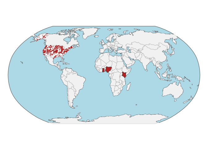
Soil site information
- Coordinates precision: precise, county, country
- Sampling depth: various
- Geography: soil taxonomy, soil horizon
- Variables available (OSSL): 15 out of 15 — see Database description for full schema
- Populated columns:
id.layer_local_c,id.kssl.lay_local_txt,id.presentation_src_txt,id.kssl.smp_local_txt,loc.country_src_txt,loc.fips.code,longitude.point_wgs84_dd,latitude.point_wgs84_dd,longitude.county_wgs84_dd,latitude.county_wgs84_dd,pedon.taxa_usda_txt,pedon.horizon_usda_txt,layer.texture_usda_txt,layer.upper.depth_usda_cm,layer.lower.depth_usda_cm
Soil laboratory information
- Total samples: 2,106
- Properties available (original): 23
- Properties standardized (OSSL): 23 — summarized in Table 1 below
- Categories: physical, chemical, hydrological, carbon & nutrients, metal elements
- Original source: see Database access
Hover over any OSSL code in the table below to see its full description.
| skim_variable | n_missing | mean | sd | p0 | p25 | p50 | p75 | p100 |
|---|---|---|---|---|---|---|---|---|
| scan_nir.1500_ref | 0 | 0.48 | 0.12 | 0.11 | 0.40 | 0.48 | 0.56 | 0.93 |
oc_usda.c729_w.pctOrganic Carbon, Total C without CaCO3, S prepMethod: usda.c729Unit: w.pct |
0 | 2.00 | 2.71 | -0.03 | 0.59 | 1.31 | 2.63 | 53.88 |
c.tot_usda.a622_w.pctCarbon, Total NCSMethod: usda.a622Unit: w.pct |
90 | 2.29 | 2.80 | 0.02 | 0.82 | 1.59 | 2.97 | 53.88 |
n.tot_usda.a623_w.pctNitrogen, Total NCS, usda.a623Method: usda.a623Unit: w.pct |
0 | 0.17 | 0.18 | 0.00 | 0.06 | 0.12 | 0.22 | 3.02 |
s.tot_usda.a624_w.pctSulfur, Total NCSMethod: usda.a624Unit: w.pct |
90 | 0.13 | 1.02 | 0.00 | 0.00 | 0.01 | 0.03 | 18.38 |
ph.h2o_usda.a268_indexpH, 1:1 Soil-Water SuspensionMethod: usda.a268Unit: index |
10 | 6.25 | 1.26 | 3.69 | 5.21 | 6.12 | 7.35 | 9.52 |
bd_usda.a4_g.cm3Bulk Density, <2mm fraction, ClodMethod: usda.a4Unit: g.cm3 |
1142 | 1.31 | 0.24 | 0.30 | 1.18 | 1.34 | 1.47 | 2.03 |
clay.tot_usda.a334_w.pctClayMethod: usda.a334Unit: w.pct |
0 | 20.55 | 14.54 | 0.00 | 9.08 | 18.33 | 28.82 | 86.69 |
silt.tot_usda.c62_w.pctSilt, Total, S prepMethod: usda.c62Unit: w.pct |
0 | 37.57 | 20.30 | 0.00 | 21.80 | 37.40 | 52.10 | 87.90 |
sand.tot_usda.c60_w.pctSand, Total, S prepMethod: usda.c60Unit: w.pct |
0 | 41.88 | 27.95 | 0.30 | 17.60 | 39.25 | 64.38 | 100.00 |
caco3_usda.a54_w.pctCarbonate, <2mm FractionMethod: usda.a54Unit: w.pct |
1413 | 5.91 | 9.49 | -0.57 | 0.26 | 1.64 | 7.61 | 89.03 |
cec_usda.a723_cmolc.kgCEC, pH 7.0, NH4OAc, 2M KCl displacementMethod: usda.a723Unit: cmolc.kg |
10 | 16.05 | 12.11 | 0.13 | 7.74 | 14.08 | 21.96 | 190.11 |
ca.ext_usda.a722_cmolc.kgCalcium, Extractable, NH4OAcMethod: usda.a722Unit: cmolc.kg |
10 | 19.23 | 31.73 | 0.00 | 2.52 | 9.78 | 22.19 | 363.64 |
mg.ext_usda.a724_cmolc.kgMagnesium, Extractable, NH4OAc, 2M KCl displacementMethod: usda.a724Unit: cmolc.kg |
10 | 3.24 | 4.52 | 0.00 | 0.68 | 1.98 | 4.29 | 82.14 |
k.ext_usda.a725_cmolc.kgPotassium, Extractable, NH4OAc, 2M KCl displacementMethod: usda.a725Unit: cmolc.kg |
10 | 0.55 | 0.73 | 0.00 | 0.14 | 0.33 | 0.68 | 11.25 |
na.ext_usda.a726_cmolc.kgSodium, Extractable, NH4OAc, 2M KCl displacementMethod: usda.a726Unit: cmolc.kg |
10 | 0.88 | 8.10 | 0.00 | 0.00 | 0.00 | 0.05 | 202.96 |
wr.33kPa_usda.a415_w.pctWater Retention, 1/3 Bar (33 kPa)Method: usda.a415Unit: w.pct |
1875 | 23.87 | 13.74 | 1.00 | 14.17 | 24.22 | 31.44 | 127.90 |
wr.1500kPa_usda.a417_w.pctWater Retention, 15 Bar (1500 kPa)Method: usda.a417Unit: w.pct |
35 | 11.59 | 7.27 | 0.08 | 6.49 | 10.81 | 15.21 | 96.14 |
al.dith_usda.a65_w.pctAluminum, Crystalline, Total Pedogenic IronMethod: usda.a65Unit: w.pct |
231 | 0.18 | 0.25 | 0.00 | 0.04 | 0.10 | 0.19 | 2.28 |
p.ext_usda.a652_mg.kgPhosphorus, Extractable, Mehlich3Method: usda.a652Unit: mg.kg |
1378 | 35.21 | 81.75 | 0.00 | 2.96 | 11.25 | 34.89 | 1358.90 |
p.ext_usda.a1070_mg.kgPhosphorus, Extractable, Mehlich3Method: usda.a1070Unit: mg.kg |
2030 | 27.26 | 35.04 | 0.36 | 6.52 | 15.96 | 39.22 | 256.44 |
k.ext_usda.a1065_mg.kgPotassium, Extractable, Mehlich3Method: usda.a1065Unit: mg.kg |
2030 | 185.49 | 136.84 | 0.00 | 82.01 | 147.45 | 256.33 | 730.19 |
ec_usda.a364_ds.mElectrical Conductivity, (w/w)Method: usda.a364Unit: ds.m |
1154 | 1.00 | 4.72 | 0.01 | 0.13 | 0.23 | 0.46 | 81.93 |
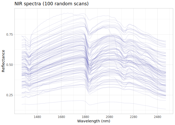
NIR
- Acquisition mode: Not available
- Intensity: reflectance
- Original range: 1350-2550
- Instrument: Neospectra
- Manufacturer: SiWare
- Instrument co-scans: Not available
- Scan repeats: 6
- Scan accessory: Not available
- Original resolution: 8-16 cm-1
- Sample preparation: Oven-dried, Sieved < 2mm
- Additional info: Not available
NIR plot