AFSIS2
AFSIS2
Soil spectral library from Africa Soil Information Service Phase II (AFSIS2)
<1,000 samples
first release (v1)
CC-BY
Database access
Data originally provided by:
- Contact: Leigh Ann Winowiecki
- Email: L.A.WINOWIECKI@cifor-icraf.org
- Original source: https://data.worldagroforestry.org/dataset.xhtml?persistentId=doi:10.34725/DVN/XUDGJY
Available files
| Type | Filename | Link |
|---|---|---|
| MIR spectra — CSV (gzip) | ossl_mir_v1.3.csv.gz |
Download |
| MIR spectra — Parquet | ossl_mir_v1.3.parquet |
Download |
| Soil lab measurements — CSV (gzip) | ossl_soillab_v1.3.csv.gz |
Download |
| Soil lab measurements — Parquet | ossl_soillab_v1.3.parquet |
Download |
| Soil site metadata — CSV (gzip) | ossl_soilsite_v1.3.csv.gz |
Download |
| Soil site metadata — Parquet | ossl_soilsite_v1.3.parquet |
Download |
Map
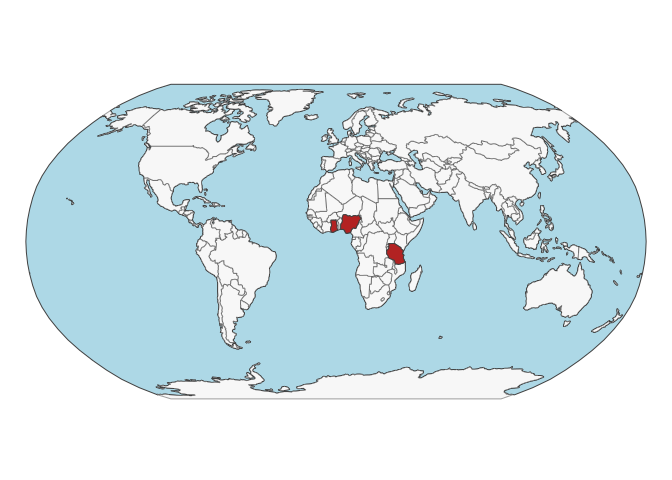
Soil site information
- Coordinates precision: precise, country
- Sampling depth: various
- Geography: soil taxonomy, landuse
- Variables available (OSSL): 10 out of 16 — see Database description for full schema
- Populated columns:
id.layer_uuid_txt,id.layer_local_c,latitude.point_wgs84_dd,longitude.point_wgs84_dd,loc.country_src_txt,observation.date.begin_iso.8601_yyyy.mm.dd,observation.date.end_iso.8601_yyyy.mm.dd,layer.upper.depth_usda_cm,layer.lower.depth_usda_cm,layer.sequence_usda_uint16
Soil laboratory information
- Total samples: 819
- Properties available (original): 14
- Properties standardized (OSSL): 14 — summarized in Table 1 below
- Categories: physical, chemical, carbon & nutrients, metal elements
- Original source: see Database access
Hover over any OSSL code in the table below to see its full description.
| skim_variable | n_missing | mean | sd | p0 | p25 | p50 | p75 | p100 |
|---|---|---|---|---|---|---|---|---|
ph.h2o_usda.a268_indexpH, 1:1 Soil-Water SuspensionMethod: usda.a268Unit: index |
11 | 6.31 | 0.80 | 4.10 | 5.80 | 6.34 | 6.76 | 8.72 |
al.ext_usda.a1056_mg.kgAluminum, Extractable, Mehlich3Method: usda.a1056Unit: mg.kg |
1 | 766.22 | 321.64 | 18.00 | 521.25 | 769.50 | 956.00 | 1851.00 |
b.ext_mel3_mg.kgBoron, Extractable, Mehlich3Method: mel3Unit: mg.kg |
526 | 1.79 | 0.70 | 0.30 | 1.00 | 2.00 | 2.00 | 4.00 |
ca.ext_usda.a1059_mg.kgCalcium, Extractable, Mehlich3Method: usda.a1059Unit: mg.kg |
1 | 1484.03 | 1801.00 | 12.00 | 404.00 | 858.50 | 1961.50 | 21565.00 |
cu.ext_usda.a1063_mg.kgCopper, Extractable, Mehlich3Method: usda.a1063Unit: mg.kg |
15 | 2.22 | 2.41 | 0.03 | 0.53 | 1.40 | 3.16 | 18.19 |
fe.ext_usda.a1064_mg.kgIron, Extractable, Mehlich3Method: usda.a1064Unit: mg.kg |
1 | 123.62 | 77.15 | 13.20 | 78.10 | 103.05 | 145.65 | 578.00 |
k.ext_usda.a1065_mg.kgPotassium, Extractable, Mehlich3Method: usda.a1065Unit: mg.kg |
2 | 280.76 | 426.69 | 5.00 | 51.00 | 125.00 | 316.00 | 3600.00 |
mg.ext_usda.a1066_mg.kgMagnesium, Extractable, Mehlich3Method: usda.a1066Unit: mg.kg |
1 | 304.29 | 365.74 | 2.00 | 89.00 | 190.00 | 368.75 | 3241.00 |
mn.ext_usda.a1067_mg.kgManganese, Extractable, Mehlich3Method: usda.a1067Unit: mg.kg |
1 | 154.51 | 120.37 | 0.70 | 58.70 | 129.55 | 225.90 | 741.10 |
s.ext_mel3_mg.kgSulphur, Extractable, Mehlich3Method: mel3Unit: mg.kg |
9 | 8.57 | 18.51 | 1.00 | 3.00 | 5.00 | 8.00 | 266.00 |
zn.ext_usda.a1073_mg.kgZinc, Extractable, Mehlich3Method: usda.a1073Unit: mg.kg |
29 | 1.79 | 3.17 | 0.06 | 0.40 | 0.90 | 2.10 | 48.79 |
n.tot_usda.a623_w.pctNitrogen, Total NCS, usda.a623Method: usda.a623Unit: w.pct |
0 | 0.10 | 0.08 | 0.01 | 0.05 | 0.08 | 0.13 | 0.53 |
c.tot_usda.a622_w.pctCarbon, Total NCSMethod: usda.a622Unit: w.pct |
0 | 1.28 | 1.04 | 0.10 | 0.58 | 0.99 | 1.66 | 7.15 |
oc_usda.c1059_w.pctOrganic Carbon, Total C without CaCO3, N prepMethod: usda.c1059Unit: w.pct |
0 | 1.26 | 1.01 | 0.10 | 0.58 | 0.99 | 1.62 | 7.09 |
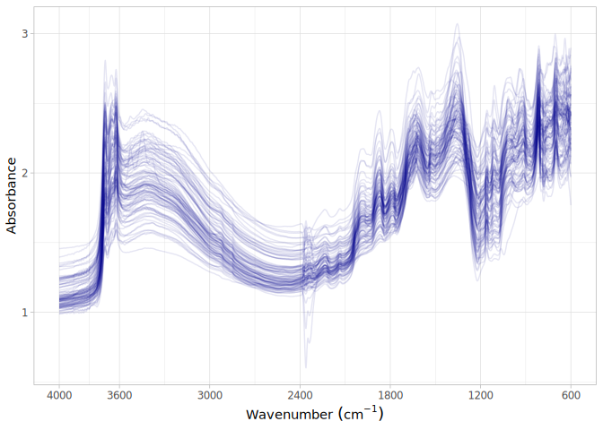
MIR
- Acquisition mode: Not available
- Intensity: absorbance
- Original range: 602-4000
- Standardized range: 600-4000
- Instrument: Tensor 27 & Alpha I ZnSe
- Manufacturer: Bruker Optics
- Scan accessory: Not available
- Sample preparation: Finely ground <0.1 mm
- Additional info: Not available
MIR plot