GEMAS
GEMAS
Soil spectral library from the Geochemical Mapping of Agricultural and Grazing Land Soil (GEMAS), Europe
4,000+ samples
first release (v1)
Other (Custom)
Database access
Data originally provided by:
- Contact: Federal Institute for Geosciences and Natural Resources
- Email: gemas@bgr.de
- Original source: https://gemas.eurogeosurveys.org/
Available files
| Type | Filename | Link |
|---|---|---|
| MIR spectra — CSV (gzip) | ossl_mir_v1.3.csv.gz |
Download |
| MIR spectra — Parquet | ossl_mir_v1.3.parquet |
Download |
| Soil lab measurements — CSV (gzip) | ossl_soillab_v1.3.csv.gz |
Download |
| Soil lab measurements — Parquet | ossl_soillab_v1.3.parquet |
Download |
| Soil site metadata — CSV (gzip) | ossl_soilsite_v1.3.csv.gz |
Download |
| Soil site metadata — Parquet | ossl_soilsite_v1.3.parquet |
Download |
Map
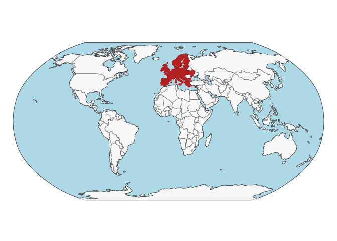
Soil site information
- Coordinates precision: precise, country
- Sampling depth: top
- Geography: soil taxonomy
- Variables available (OSSL): 10 out of 10 — see Database description for full schema
- Populated columns:
id.layer_uuid_txt,id.layer_local_c,loc.country_src_code,site.land.use_src_code,site.alt_src_m,longitude.point_wgs84_dd,latitude.point_wgs84_dd,layer.upper.depth_usda_cm,layer.lower.depth_usda_cm,layer.sequence_usda_uint16
Soil laboratory information
- Total samples: 4,131
- Properties available (original): 12
- Properties standardized (OSSL): 4 — summarized in Table 1 below
- Categories: physical, chemical, carbon & nutrients, metal elements
- Original source: see Database access
Hover over any OSSL code in the table below to see its full description.
| skim_variable | n_missing | mean | sd | p0 | p25 | p50 | p75 | p100 |
|---|---|---|---|---|---|---|---|---|
c.tot_iso.10694_w.pctCarbon, Total NCS, ISO 10694Method: iso.10694Unit: w.pct |
0 | 3.91 | 4.94 | 0 | 1.64 | 2.68 | 4.34 | 50.10 |
oc_iso.10694_w.pctOrganic Carbon, ISO 10694Method: iso.10694Unit: w.pct |
0 | 3.27 | 4.76 | 0 | 1.40 | 2.10 | 3.40 | 49.00 |
cec_usda.a723_cmolc.kgCEC, pH 7.0, NH4OAc, 2M KCl displacementMethod: usda.a723Unit: cmolc.kg |
0 | 19.14 | 9.17 | 0 | 11.90 | 17.50 | 24.90 | 49.88 |
ph.cacl2_iso.10390_indexpH, 1:5 Soil-CaCl2 Suspension, ISO 10390Method: iso.10390Unit: index |
0 | 5.78 | 1.14 | 0 | 4.81 | 5.62 | 6.97 | 8.06 |
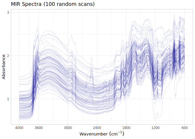
MIR
- Acquisition mode: Not available
- Intensity: absorbance
- Original range: 450-7800
- Standardized range: 600-4000
- Instrument: Spectrum-One™ FT-IR Spectrometer
- Manufacturer: PerkinElmer Inc. (MA, USA)
- Scan accessory: Not available
- Sample preparation: Oven dried, Sieved<2mm
- Additional info: extended range KBr beam-splitter, a high intensity ceramic source, a deuterium triglycine-sulphate (DTGS) Peltier-cooled detector; Background reference scans were carried out using silicon carbide discs (PerkinElmer Life and Analytical Sciences Pty Ltd., Australia)
MIR plot