Geocradle
Geocradle
Soil spectral library from the Geocradle region (Balkans, Middle East, and North Africa)
1,000+ samples
first release (v1)
ODbL
Database access
Data originally provided by:
- Contact: Nikos Tsakiridis
- Email: tsakirin@auth.gr
- Original source: http://datahub.geocradle.eu/dataset/regional-soil-spectral-library
Available files
| Type | Filename | Link |
|---|---|---|
| Soil lab measurements — CSV (gzip) | ossl_soillab_v1.3.csv.gz |
Download |
| Soil lab measurements — Parquet | ossl_soillab_v1.3.parquet |
Download |
| Soil site metadata — CSV (gzip) | ossl_soilsite_v1.3.csv.gz |
Download |
| Soil site metadata — Parquet | ossl_soilsite_v1.3.parquet |
Download |
| VisNIR spectra — CSV (gzip) | ossl_visnir_v1.3.csv.gz |
Download |
| VisNIR spectra — Parquet | ossl_visnir_v1.3.parquet |
Download |
Map
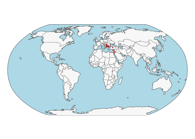
Soil site information
- Coordinates precision: precise, country
- Sampling depth: various
- Geography: soil taxonomy, elevation
- Variables available (OSSL): 13 out of 13 — see Database description for full schema
- Populated columns:
id.layer_uuid_txt,id.layer_local_c,latitude.point_wgs84_dd,longitude.point_wgs84_dd,observation.date_src_yyyy.mm.dd,layer.lower.depth_usda_cm,loc.country_src_txt,site.clim.koeppen_src_code,site.alt_src_m,pedon.taxa_wrb_code,pedon.taxa_wrb_txt,pedon.taxa_usda_txt,layer.texture_usda_txt
Soil laboratory information
- Total samples: 1,753
- Properties available (original): 18
- Properties standardized (OSSL): 7 — summarized in Table 1 below
- Categories: physical, chemical, carbon & nutrients
- Original source: see Database access
Hover over any OSSL code in the table below to see its full description.
| skim_variable | n_missing | mean | sd | p0 | p25 | p50 | p75 | p100 |
|---|---|---|---|---|---|---|---|---|
sand.tot_usda.c405_w.pctSand, Total, N prepMethod: usda.c405Unit: w.pct |
264 | 53.48 | 22.85 | 0.40 | 36.85 | 54.00 | 69.00 | 99.00 |
clay.tot_usda.a334_w.pctClayMethod: usda.a334Unit: w.pct |
77 | 21.26 | 16.01 | 0.00 | 9.39 | 17.00 | 29.10 | 94.80 |
silt.tot_usda.c407_w.pctSilt, Total, N prepMethod: usda.c407Unit: w.pct |
264 | 26.67 | 14.31 | 0.00 | 16.00 | 26.00 | 37.40 | 68.00 |
oc_iso.10694_w.pctOrganic Carbon, ISO 10694Method: iso.10694Unit: w.pct |
132 | 0.74 | 0.84 | 0.00 | 0.29 | 0.58 | 0.94 | 20.75 |
caco3_iso.10693_w.pctCarbonate, ISO 10693Method: iso.10693Unit: w.pct |
388 | 6.83 | 14.87 | 0.00 | 0.00 | 0.20 | 3.40 | 89.99 |
ph.h2o_usda.a268_indexpH, 1:1 Soil-Water SuspensionMethod: usda.a268Unit: index |
1141 | 7.22 | 1.09 | 3.50 | 6.50 | 7.44 | 8.01 | 10.07 |
ec_iso.11265_ds.mElectrical Conductivity, ISO 11265Method: iso.11265Unit: ds.m |
1412 | 2.29 | 9.32 | 0.02 | 0.16 | 0.67 | 1.42 | 120.00 |
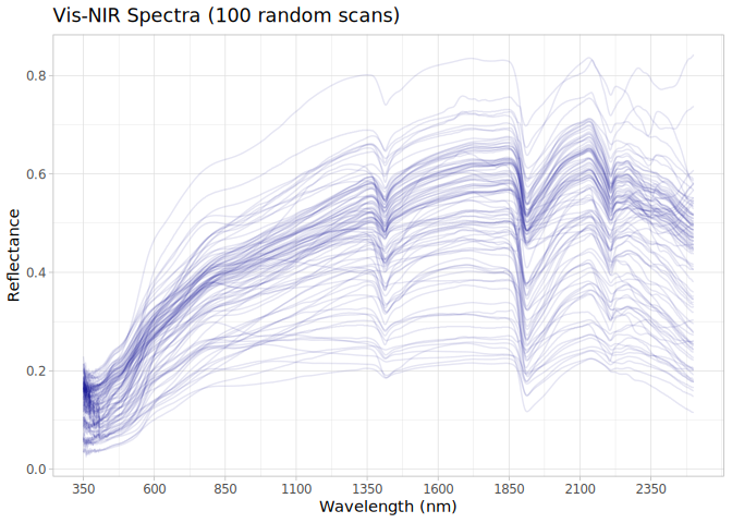
VNIR
- Acquisition mode: Not available
- Intensity: reflectance
- Original range: 350-2500
- Instrument: ASD FieldSpec Pro & PSR+ Spectrometer
- Manufacturer: (PANanalytical BV, Boulder, CO, USA formerly Analytical Spectral Devices) & Spectral Evolution Inc., Lawrence, Massachusetts,USA
- Instrument co-scans: 10
- Scan repeats: Not available
- Scan accessory: Not available
- Original resolution: 1
- Sample preparation: Air-dried, Sieved < 2 mm
- Additional info: Not available
VNIR plot